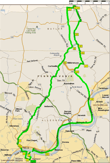
| Ride |
To |
|
Then |
|
0.0 |
|
R N Highland Ave. |
| 0.1 |
0.1 |
|
R Hampton St |
| 0.6 |
0.7 |
|
R Chislett St |
| 0.6 |
1.3 |
|
L Greenwood St |
| 0.1 |
1.4 |
|
R Morningside Ave |
| 0.1 |
1.5 |
|
L Baker St |
| 0.5 |
2.0 |
|
BL Butler St |
| 0.2 |
2.2 |
|
R Rd Fleming Bridge |
| 0.3 |
2.5 |
|
Left lane (to Sharpsburg) |
| 0.5 |
3.0 |
|
R Butler St |
| 0.5 |
3.5 |
|
R Farmerie St |
|
3.5 |
|
L SR-8 |
| 0.7 |
4.2 |
|
R Saxonburg Blvd |
| 2.5 |
6.7 |
|
Open grate bridge-use middle of lane |
| 10.1 |
16.8 |
|
Short stop at Culmerville Popeye's on left |
| |
16.8 |
|
ST stay on Saxonburg Blvd—35 mile option goes right |
| 1.6 |
18.4 |
|
R Anderson Rd |
| 0.8 |
19.2 |
|
L Sun Mine Rd—44 mile option goes straight |
| 3.3 |
22.5 |
|
L SR-228 [Ekastown Rd] |
|
22.5 |
|
R Saxonburg Blvd |
| 0.1 |
22.6 |
|
L Knoch Rd |
| 1.7 |
24.3 |
|
R at T onto Golden City Rd [W Main St] |
| |
|
|
Route goes R, but snack stop is out and back 0.1 L at
Citgo |
| |
|
|
(bathrooms at Dollar General, pizza shop, public
library or Roebling Park) |
| 0.7 |
25.0 |
|
L State St (pizza shop) |
| |
|
|
(for public library, continue on Main St, do not
turn onto State St) |
| 0.3 |
25.3 |
|
R W Water St |
| 0.3 |
25.6 |
|
R N Rebecca St (Roebling Park) |
| 2.0 |
27.6 |
|
R SR-228 [Ekastown Rd] |
| 0.2 |
27.8 |
|
L Lardintown Rd |
| 1.6 |
29.4 |
|
L stay on Lardintown Rd |
| 0.1 |
29.5 |
|
BR stay on Lardintown Rd |
| 1.6 |
31.1 |
|
BR stay on Lardintown Rd |
| 0.9 |
32.0 |
|
BR stay on Lardintown Rd |
| 1.8 |
33.8 |
|
R at T onto Bull Creek Rd [Red Belt] |
| 0.4 |
34.2 |
|
L SR-908 Ext |
| 1.1 |
35.3 |
|
BL Bakerstown Rd |
| 0.5 |
35.8 |
|
R Gillespie Rd |
| 0.6 |
36.4 |
|
BL Days Run Rd [Kurn Rd] |
| 2.6 |
39.0 |
|
L Baileys Run Rd |
| 0.6 |
39.6 |
|
R Freeport Rd (Sheetz 0.4 miles
on right) |
| 4.0 |
43.6 |
|
Ice cream at Glen's Custard on left |
| 6.7 |
50.3 |
|
BR ramp to Aspinwall & Sharpsburg |
| 2.4 |
52.7 |
|
R ramp to Highland Park Bridge |
| 0.6 |
53.3 |
|
R ramp to Butler St [SR-8] |
| 0.2 |
53.5 |
|
L One Wild Place [The Hill Rd] |
| 0.6 |
54.1 |
|
R at hairpin turn |
| 0.1 |
54.2 |
|
L Bunkerhill St |
| 0.2 |
54.4 |
|
R N Highland Ave |
| 0.3 |
54.7 |
|
Finish at Tazza D'Oro |
| |
|
|
|
| |
|
|
44 mile option |
| |
|
|
Follow 56 mile route to mile 19.2, then: |
| |
|
|
|
| Ride |
To |
|
Then |
| |
19.2 |
|
ST Anderson Rd |
| 0.8 |
20.0 |
|
R Lardintown Rd |
| 1.1 |
21.1 |
|
BR stay on Lardintown Rd |
| 1.8 |
22.9 |
|
R at T onto Bull Creek Rd [Red Belt] |
| 0.4 |
23.3 |
|
L SR-908 Ext |
| 1.2 |
24.5 |
|
BL Bakerstown Rd |
| 0.5 |
25.0 |
|
R Gillespie Rd |
| 0.6 |
25.6 |
|
BL Days Run Rd [Kurn Rd] |
| 2.6 |
28.2 |
|
L Baileys Run Rd |
| 0.5 |
28.7 |
|
R Freeport Rd (Sheetz 0.4 miles
on right) |
| 4.0 |
32.7 |
|
Ice cream at Glen's Custard on
left |
| 6.7 |
39.4 |
|
BR ramp to Aspinwall & Sharpsburg |
| 2.4 |
41.8 |
|
R ramp to Highland Park Bridge |
| 0.6 |
42.4 |
|
R ramp to Butler St [SR-8] |
| 0.2 |
42.6 |
|
L One Wild Place [The Hill Rd] |
| 0.6 |
43.2 |
|
R at hairpin turn |
| 0.1 |
43.3 |
|
L Bunkerhill St |
| 0.2 |
43.5 |
|
R N Highland Ave |
| 0.3 |
43.8 |
|
Finish at Tazza D'Oro |
| |
|
|
|
| |
|
|
38 mile option |
| |
|
|
Follow 56 mile route to mile 16.8, then: |
| |
|
|
|
| Ride |
To |
|
Then |
| |
16.8 |
|
R Bakerstown Culmerville Rd [Red Belt] |
| 0.2 |
17.0 |
|
L Bakerstown Rd |
| 0.1 |
17.1 |
|
ST Bakerstown Rd [do not follow Red
Belt] |
| 1.8 |
18.9 |
|
ST Bakerstown Rd |
| 0.5 |
19.4 |
|
R Gillespie Rd |
| 0.6 |
20.0 |
|
BL Days Run Rd [Kurn Rd] |
| 2.6 |
22.6 |
|
L Baileys Run Rd |
| 0.5 |
23.1 |
|
R Freeport Rd |
| 4.0 |
27.1 |
|
Ice cream at Glen's Custard on
left |
| 6.7 |
33.8 |
|
BR ramp to Aspinwall & Sharpsburg |
| 2.4 |
36.2 |
|
R ramp to Highland Park Bridge |
| 0.6 |
36.8 |
|
R ramp to Butler St |
| 0.2 |
37.0 |
|
L One Wild Place [Hill Rd] |
| 0.6 |
37.6 |
|
R at hairpin curve |
| 0.1 |
37.7 |
|
L Bunkerhill St |
| 0.2 |
37.9 |
|
R N Highland Ave |
| 0.3 |
38.2 |
|
Finish at Tazza D'Oro |
|
|
|
|
|
|
|
back to Cue
sheets and maps
back to Tazza D'Oro Home |